
CAPgrids: CAP Search Grids |
Select your sectional (CAPgrids will suggest the closest one to you.) Then use this area to download Google Earth overlays, complete gridded sectionals, Garmin 695 flight plans files, and other information. Sectionals updated 21-March-2024 |
Find a Grid |
Use this section if you have Lon/Lat coordinates and need to find the associated grid. We'll find the grid, then provide the grid corners, below. |
Find Grid Corners
|
Select a sectional and a grid identifier. The grid's average magnetic variation is calculated from the current NOAA model and adjusted for yearly drift. It may not agree with the isogonic lines printed on aeronautical charts. |
|
|
This section shows a satellite map layered over a terrain map. Use the slider to adjust the transparency of the layers. You may also download an overlay to use with Google Earth. This overlay is compatible with the Sectional and Terminal Chart overlays. Click the Print button (above) to print the Google Map and grid coordinates on one page: 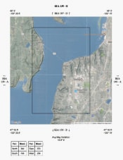
|
|
|
This section shows the five nearest airports. Private, military, and public airfields are included. |